|

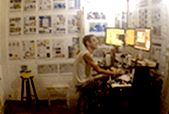
Ola meu nome é Paulo Chiacchio, apelido Poike,
Gráfico por natureza, da tipografia aos meios digitais,
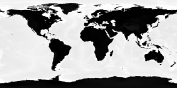
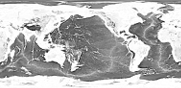
me interessei pelo desenho do Oceano Pacifico no início dos anos 2000, e baixando e analisando os mapas da NOAA, indentifiquei esse padrão de cordilheiras oceânicas que chamo de Padrão de Marcas de Arrasto,
sem uma resposta da academia sobre este padrão, rotulados como formações naturais, notei que esse padrão explica exatamente o movimento continental,
a partir desta interpretação desenvolvi essa teoria que explica o gatilho para o movimento continental, um evento que desenhou a topografia atual da terra,
A Ilha de Páscoa tem papel importante nesta teoria como ponto inicial do derrame, sendo criada neste evento, foi tranformada em um teatro de pedra que explica esse evento, esculpida pelos povos que sobreviveram,
muitos outros povos deixaram registros similares pelo mundo a fora, neste trabalho eu reuno todas as informações que consigo agregar sobre este evento, e as torno disponíveis para estudo em fomato pdf de boa resolução,
migrações como Clovis e Solutrean, San Bush Man e Autralian Aborigene, Extinção da Mega Fauna e muitos outros assuntos estão em pauta,
seja bem vindo,
esta é a minha teoria :)
então haverá uma série de vídeos para expor esse quebra-cabeça,
há alguns fatores-chave nesta teoria, como linhas costeiras do Oceano Pacífico com o padrão de marcas de arrasto do oceano profundo, e como o Monte Poike na Ilha de Páscoa, como uma representação humana deste evento, chamado por nós de o Evento do Derrame do Pacífico.
para começar gostaria de dizer que esta teoria é uma colcha de retalhos de informação, reunidas desde o início de 2000,
todos os rascunhos e mapas estão disponíveis neste site, e estamos revisando e retrabalhando todo o material, |
 |
|
|
|
|
 João Paulo Chiacchio
(in memorian)
|
|
|
|
|
|
|
|
|
|
|
|

Hello my name is Paulo Chiacchio, nickname Poike,
Graphic by nature, from typography to digital media,
I became interested in the design of the Pacific Ocean in the early 2000s, and by downloading and analyzing NOAA maps, I identified this pattern of ocean ridges that I call the Drag Marks Pattern,
without a response from the academy about this pattern, labeled as natural formations, I noticed that this pattern exactly explains the continental drift,
from this interpretation I developed this theory that explains the trigger for continental drift, an event that shaped the current topography of the earth,
Easter Island plays an important role in this theory as the starting point of the drop, being created in this event, it was transformed into a stone theater that explains this event, carved by the people who survived,
many other peoples left similar records around the world, in this work I gather all the information I can add about this event, and make them available for study in pdf format with good resolution,
migrations like Clovis and Solutrean, San Bush Man and Autralian Aborigene, Extinction of Mega Fauna and many other subjects are on the agenda,
be welcome,
this is my theory :)
so there will be a series of videos to expose this puzzle,
There are some key factors in this theory, such as Pacific Ocean shorelines with the deep ocean drag marks pattern, and like Mount Poike on Easter Island, as a human representation of this event, called by us the Pacific Drop Event.
to begin with I would like to say that this theory is a patchwork of information, gathered since the beginning of 2000,
all drafts and maps are available on this site, and we are reviewing and reworking all material, |
|
Nossa Chave PIX:
Our PIX key:
|
|
poike@cybergarage.com.br |
|
|
|
Please note: If you download ocean floor maps from NOAA like: “ETOPO1_Ice_g_geotiff.tif” and it show’s almost a flat black and white, you have to adjust the levels in the image to see better contrast, and select the black part and invert the image and adjust levels again to see the dry land mountain belts.
|
*You can download the edited version on our website under "Earth Maps"
if there is a missing or improper credit you can tell us, please let us know, E-mail: info@poikestheory.com.br
|
|
|
I dedicate all the inspiration and efforts to keep on this work
to my beloved son, Heitor Celestino,
and the memory of my father, João Paulo Chiacchio (1944 / 2006)
|
|
|
|
|
Envie suas questões ou comentários para:
E-mail: info@poikestheory.com.br
Telefone: (12) 98122.0399
Rua Romeu Carnevalli, 264 - Bela Vista,
São José dos Campos, São Paulo,
Brasil, CEP: 12.209-005
|
|
Send your questions or comments:
E-mail: info@poikestheory.com.br
Phone: 55 (12) 98122.0399
Rua Romeu Carnevalli, 264 - Bela Vista,
São José dos Campos, São Paulo,
Brasil, CEP: 12.209-005
|
|
|